

Circumnavigating the Çandir Stream Valley

Let me start by saying that Antalya and Turkey, in general, blew me away, and I’m ever so hooked now. The amount of history, delicious food, and abundance of mountains is unmatched to anywhere I’ve been to so far worldwide.
And that’s an understatement.
Bold statements, I know.
But I know you will be hooked by the end of this article as well.
At the time of writing this, I have about 6 stories to share with you about my trip to Antalya, and I’m starting in a random order rather than writing about rides in the order I rode them.
Two weeks into my trip to Antalya, I finally built up some fitness, enough not to bonk, at least! You see, due to some life-changing events, I had to be off the bike for about 3 months. I switched to running as that was the safest form of training I had access to during that time.

Why does this matter?
Well, to put it shortly, Antalya is the hardest place I’ve ever ridden in, even harder than riding in the Canary Islands!
Antalya is located in southern Turkey, surrounded by the Taurus Mountains from the west, north, and east. The Taurus mountains territory is a geological, historical, and cultural wonder. From the coastline, the mountains rise sharply like a giant wall separating the sea from the inland. From a close distance, it is hard to distinguish where the mountains start and where the clouds end due to the light-colored peaks and staggering elevation.
For about 4 weeks or so, I spent time exploring the Western Taurus mountains. These mountains are rugged, and they are as old as time. One can simply reach the highlands from sea level in under 22 miles on a bike. To put that into perspective, that’s starting at 0ft and reaching anything beyond 6500ft in elevation!
And the best part about it is that you can almost see the whole climb from the bottom. A statement from the mountains not to take them lightly. These mountains homed many nations across thousands of years, from prehistoric times to the Romans and to the ottomans. And it's not something that you have to dig deep to find out about. As a matter of fact, the amount of ruins of past nations across the Western Taurus is something that I still struggle to wrap my head around.
A true open-air museum.

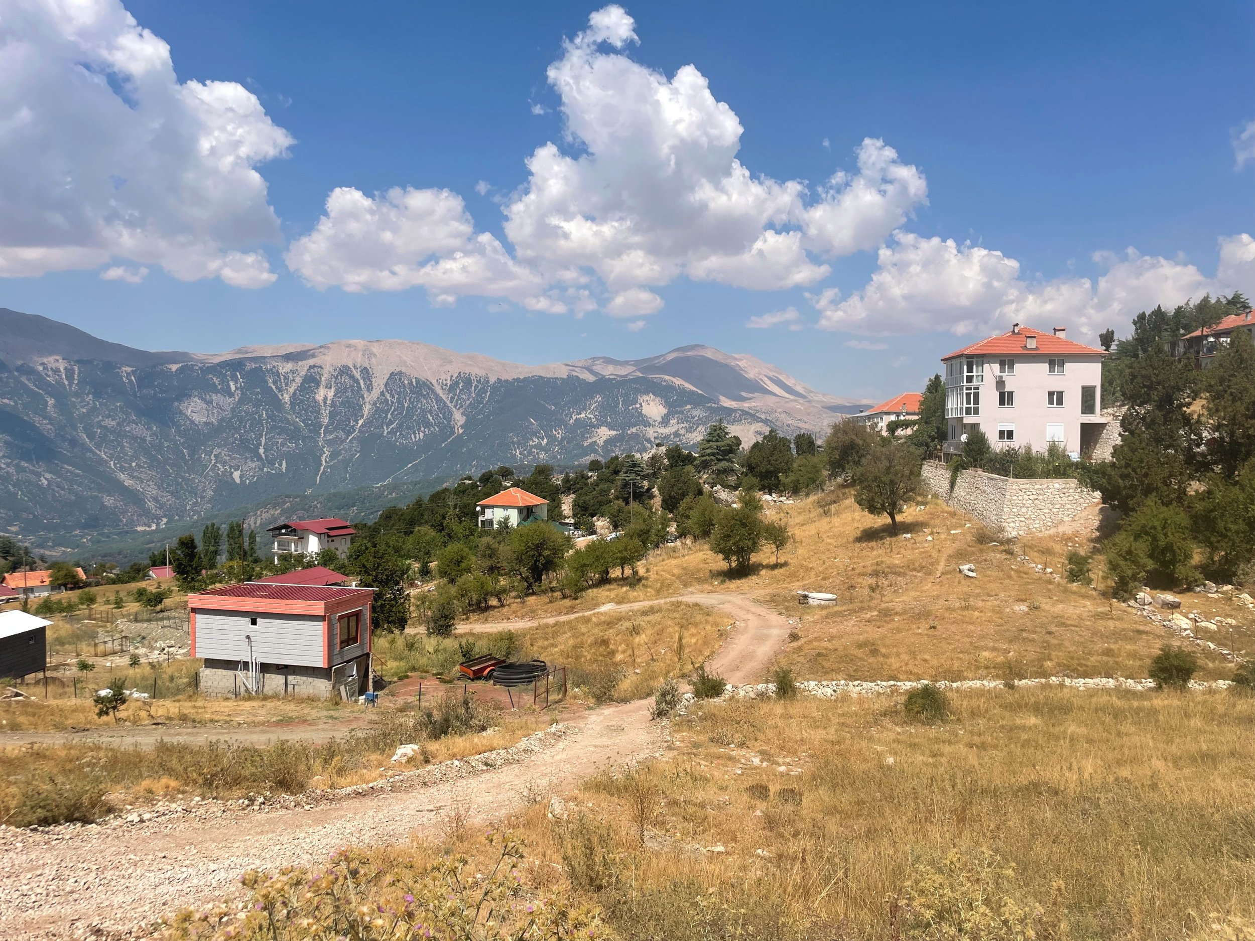
By the time I got a good grasp on riding in the area, I felt the need to explore every climb I had access to in the Western Taurus mountains. Over the course of a few rides, I was intrigued by a village that sat on a high ridge at the crown of a U-shaped valley. The Village appeared like a few white dots scattered around at high elevations.
Driven by curiosity, I spent some time on the trusty RWGPS Route Planner, as I usually do! I found out that I already rode close to that village on my way back from Gedelme Castle (stay tuned for that ride!). Where I dropped back into Antalya on the southern part of the valley, down the main road, so I figured it would be great to circumnavigate the valley and get a good survey of the area.
Where did the title of this article come from?
Well, I found it difficult to gather detailed information about certain things in Turkey on the web, so I worked with what I got. I couldn’t locate the name of the valley, and I somehow forgot to ask the locals for it. But I noticed the significance of a stream that splits the valley into two halves, north and south.

The Çandir Stream’s headwater sits just below the ridge I wanted to ride up to. A quick look at the maps revealed a road that climbed up the northern part of the valley to a few scattered villages up high. So I put together the route and headed out the following morning.
One thing to know about riding in Antalya in August is that things get hot, like really hot. The sun is relentless, and so is the wind at times. The best thing to do is leave as early as you can, and in my case, I left my Airbnb around 7 am. The idea is to get to high elevation before the heat kicks in; that way, you’d be sheltered by the lower temperatures in higher elevations.
And speaking of elevation, remember what I wrote about how big and steep these mountains can be?
That’s both a blessing and a curse. A blessing because you can escape the heat in a short distance, and a curse because the gradients can easily and frequently average in the double digits. In my case, my accommodation was right at the bottom of the mountains, so it was straight up for me for most of the rides I did there.
The Ride
However, this ride started with a lower caliber gradual climb. I started in the neighborhood of Hurma and paralleled the dry river stream bed. I headed towards the prominent peak of the appropriately named Sivri Dagi (pointed mountain), standing tall at the frontline looming over the villages below. A view you have to see in real life to feel the magnitude of these mountains.
Although you gain more than 750ft over the first 10 miles, that was probably the flattest 10 miles I road in Antalya. Those 10 miles cut around the base of Sivri Dagi through a small farming village called Hacisekililer. What I love about these roads is how thick the forest is, given how close Antalya is to the hotter and dryer regions of the area. A lot of change in vegetation occurs over the course of a few miles.
At the end of the first 10 miles, I reached what seemed like a touristy area with lots of mountain-style restaurants looking over the Çandir Stream, where I stopped to fill up on water from a spring. Yet another thing that I love about Antalya is the abundance of water springs. I pretty much stopped worrying about making sure my bottles were full because I knew there would be springs around within miles, regardless of where I was.
A quick fill before the next 10 miles, which are completely different with respect to difficulty and beauty.


From the spring, I rode up an Hors Catégorie climb, a French term for the most difficult type of climb in cycling terms. I was cooked right off the bat, with an average of 10% and a gain of more than 2000ft in 4 miles. I scaled back a bit when I finally reached the cooler temperatures, just before a tiny village and mosque on the side of the mountain looking over the valley.
I have to say, the view of mosques scattered around the mountains with their unique architecture is a view to be seen in real life; simply wonderful.
As I ascended, the valley grew wider as I neared the U-shaped end. The scenery from the road is something, unlike anything I’ve seen before, mountains on top of mountains and highlands as far as the eyes can see.


Eventually, I reached yet another small village, Yarbaşıçandırı. Where I stopped at a grocery store along the way for a snack. A quick tip about riding in Turkey, I noticed that almost all of the grocery stores in the mountain have some type of hot food. In this case, Ali, the store owner, suggested I get half a sandwich of mountain-style cheese, with Turkish cured sausage with a spicy pepper spread, and of course çay, you can’t have enough Turkish tea.
Ali’s hospitality wasn’t something out of the ordinary, as I found nothing but generosity and warmth from the people in the mountains. I almost felt like an expected guest. That sandwich was so delicious my mouth water just at the thought of it.
Food is on a whole other level in Turkey.


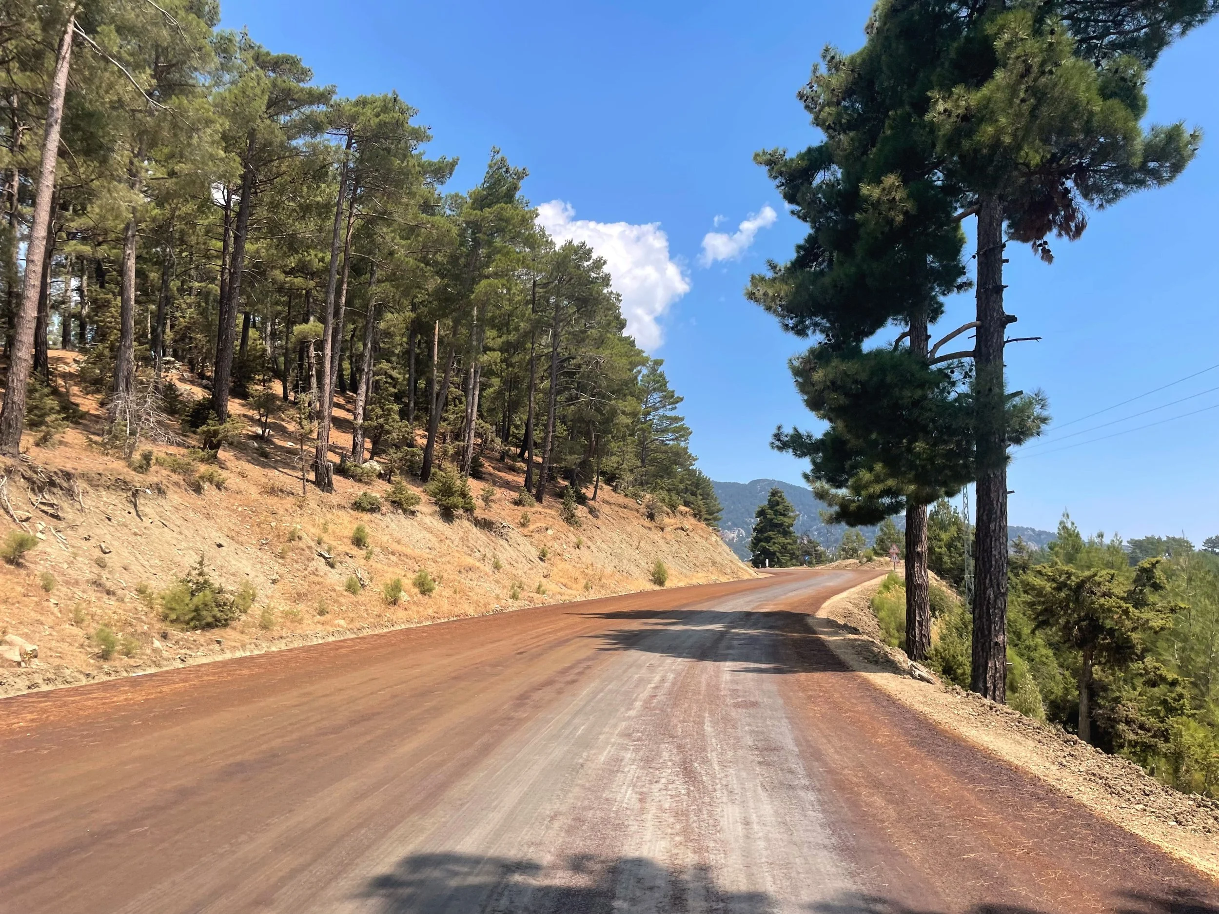
Well-fed and caffeinated, thanks to Ali, I continued my way up the mountain. Up until that point, the pavement was in good condition until I reached the end of it just past Yarbaşıçandırı. From what I gathered online, a lot of mountain roads have recently been reformed from gravel roads to somewhat more staple gravel roads.
It was chunky for my 28mm tires, but nothing a good handlebar grip couldn’t handle. Although to speak the truth, it's always a lot easier climbing up loose gravel than it is to descend it. Regardless, I continued upwards.
The roads bend and curve to the contour of the mountain I was on. With every bend, I see a place I want to bike to. When the road curved around a hairpin, a whole other mountain revealed itself above yet another mountain.
Something I could never get used to because it's too surreal!


I stopped to check out the view just to notice the same small white dots that drew me to do this ride. Turns out the recently graded gravel road takes you even further up the mountain to a cluster of cottages just below the timberline of Tunç Dağı (Bronze Mountain), an 8707ft tall mountain towering above the Çandir Stream Valley.
Although I loved this whole route, as it was something I wish you could try at least once in your life, I have to say that the five miles between mile markers 20.5 and 25.5 are out of this world.
The sky opened up, and by then, most of the peaks around the area were visible. A slight breeze pushed me up the road and moved the clouds above me.
Finally! Made it up to the ridge which caps the Çandir Stream Valley from the western end. The beauty of riding on ridges is that you get views of both sides as you ride along. The views to the east capture the full magnificence of the Valley. While views to the west show the power of seismic activities in shaping the mountainous highlands and pushing the land closer to the heavens.


The views left me speechless, my jaw dropped, and my heart was full.
A few miles down the road, I reached a small but bustling village crowning the ridge facing the Bey Dağlari (Bey Mountains) to the west, basking in the sun about 5000ft high. I started getting hungry again by the time I got there and went ahead to look for my next meal. In the middle of town, I spotted a group of cyclists (looking at you, Ogla!) at the bakery and decided to stop there. I mean, that place had to be the go-to spot if you were going to climb up a massive mountain!
The group was kind enough to chat a bit and ask about my ride and vice versa. They had been wondering about the road conditions from the side I climbed as it was not the main road to get to this point.


The food, company, and weather made it very difficult to jump back on the saddle. I simply wanted to find a bench and just look at the mountains around me. Seriously, nowhere else I’ve been to offers what the Western Taurus mountains offered!
I know I seem like I exaggerate at times, but for real, the photos speak for themselves.
After making the hard decision to get back on the bike, I waved goodbye to that group and headed towards the main road, which was about 3 miles away down a gravel road. But it took me a lot longer to cross those 3 miles than usual. I just had to stop every hundred yards or something to take photos and videos and check out the various types of pine and cider that dominate the area.


Alas, I reached the highway and tucked in for the long descent back into Antalya through some of the best scenery anywhere around. I mean, I know I already paid the climbing toll, but I would’ve been glad to continue climbing up those gravel roads even further! Perhaps I do owe myself another visit with my B-road next time.
And I hope next time is just around the corner.
Until then, part of my soul roams the highlands of the Western Taurus Mountains.