

The Village of Masca

By the end of my ride up the famous Mt. Teide, I understood why Tenerife is known as the Queen of the Canaries and why the pros train here. Ample sun, continuous steep climbs, microclimates to choose the perfect riding weather, and most importantly, the longest descents I’ve ever ridden (hours on end…!)
However, Mt. Tiede turned out to be a good introduction to what Tenerife had to offer.
I only had 3 days in Tenerife, and I needed to maximize every minute. With very little energy, I had to squeeze in another epic ride, so I chose to ride to Masca based on the advice of local cyclists.
Masca is the most beautiful village on the island, and I’d argue that it’s the most beautiful in the whole of the Canary Islands. The village is situated in a narrow yet very steep valley west of Tenerife. Hidden between the folds of the ancient Teno Massif folds, surrounded by a sea of native flowers filling the whole canyon with a distinct floral smell that I could only describe as sweet cherry and grape (think candy flavor) with a hint of lavender.
The folks at Freemotion (where I rented my bike) were keen on getting me to ride to Masca. However, understanding that going it counterclockwise meant I’d be climbing the hardest climb on the island.
The Route:

With tired legs, after I had climbed the longest climb in Europe, followed by the toughest climb on the island sounded like I needed a few pizzas and curry the night before. So I got on that recovery train as fast as I got done with Teide. A few meals, a bottle of Aquarius (electrolyte drink), and a good night's rest were very much needed!
The morning came, and I woke up with a case of noodle legs, but no excuse was going to stop me from trying, at least. The ride started from Los Cristianos, a bustling tourist town on the coast, before heading up the side of Mt. Tiede. Getting out of town is towards the mountain. I headed north, passing through the half a dozen pueblos on the side of Teide facing the Atlantic Ocean, with multiple tunnels and lava flow areas. The first 20 miles or so mainly were just a connector to get to the west end point of Tenerife.


The “real” ride starts just past the small village of Arguayo, which sits just below a pass that separates the mountainside from the appropriately named Valle de Arriba (the valley above). Most of the scenery up until Arguayo was mostly scattered pine and bushes. However, as you go around the curve and the upper valley reveals itself, a sudden flora change occurs. A valley covered in small shrubs with white flowers and a dense forest in the background.
Effectively, I entered a different climate zone on the island.
I continued down the other side to Santiago del Teide, a town in the heart of the upper valley; something caught my attention as I left town and continued north. Well, a lot of things did, actually!

Looking up the pass I was climbing, and I noticed clouds rolling like the tide, slowly washing over the cliffs and dissolving under the intense sunshine. Beyond the cliffs, heavy grey clouds seemingly suspended above the upper valley from the north side. By the time I got around the last few bends in the road, the peak of Mt. Tiede became visible, showing its western side, towering above all else.
However, as magical as that view was, I couldn’t help but be mesmerized by the sea of clouds rushing in from the ocean on the other side of the mountain, more than 3700ft below. At the port (summit), I found a sideroad that climbed further above the valley. I lingered around because of the way the wind was blowing the clouds over the cliffs, a scene I rarely observed.


Following the back road for a bit more, the fog engulfed the road, leaving you in a sea of clouds, like a scene from Silent Hill. And just like the tidal waves, it would eventually retract, revealing the magnificence of the Tiede once again.
And the song continued for the next 10 mins I stood there.
Sensing the cold breeze rushing up and over from the northern side contrasted with the warm sun on the southern side is a good example of why the archipelago is known for its microclimates. So I put on my gilet and descended down towards the north.
The thick clouds got more intense over the next 8 miles, and I was shriving from the cold. I recall seeing a few bikepackers climbing up the road and thinking about how perfect the temperature must’ve been for climbing, just chilly enough to keep you from overheating.


Suddenly, however, I found myself below the inversion as I neared the northern coast. The 12-mile descent went through a handful of small villages with the best view of the Atlantic and endless switchbacks.
The view when the fog lightened up a bit stopped me in my tracks. Mossy green mountainside with a mix of tropical forests and massive basalt cliffs above the coastline.
How is that even real?
The other side of the mountain is a high desert!
I continued westward along the rugged coast to the town of Buenavista del Norte, which sits at the mouth of the lower valley below the rugged terrain of the western point. A quick lunch stop of Canarian potatoes and locally made sheep cheese, something so simple yet delicious.
Leaving behind the town of Buenavista, the climb immediately kicks up into high gear with the whole climb in sight. That’s one of the things that captured me in the Canary Islands, the visibility of these climbs from the bottom to the top. It occurred to me on the climb that I had forgotten about my tired legs from the past 5 days of riding. Perhaps I lend that to the endless beauty of Tenerife or the mojo sauce topping the potatoes?


The climb heads south up a narrow valley with rugged mountains crowning the southern side, cutting off this valley from the rest of the area with only a few ways in and out. Similar to the descent I took down to the western side, this climb also boasts endless switchbacks. However, this side was much quieter and less busy than the rest of the area I passed through. Occasionally passing by older residents sitting on the porch, they wave at you as you climb up. Perhaps it’s all too common for the residents of Tenerife to coexist with cyclists, given the legendary status of the archipelago.
Halfway up the climb, a towering butte occupies the horizon, with a few of its sides collapsed due to the excavation and extraction of minerals by the locals. The road arches around the butte and meanders alongside the crown of the valley. Gaining a bit more elevation confirmed that the pass I saw from the bottom, indeed, was where I needed to get to.


The pass sitting along the saddle ahead.
The closer to the pass I got, the more unstable the weather was. It felt like I was nearing that same convergence zone where the clouds were rushing down the side of the mountain. However, this time, the afternoon sun was piercing through the cold and cloudy reign of this part of the island.
By the time I reached the pass, I had noticed that the two bikepackers I had seen climb up earlier in the day were also at the pass. These two dudes were from Germany on a short holiday trip to ride around the island. They mentioned how warm the weather was on the other side (where I’m headed next), whereas it was brisk on my side.
Microclimates at their best.
At the pass, which is shaped like a razor's edge, I could clearly see the separation of the two microclimates in real-time, with the grey clouds and chilly breeze on one side and the warm sunshine on the other. So I bid farewell to the cold and descend towards the warmth.


*The three photos above were taken from the same point. All I did was turn around!
The wind shifted slightly from a cold tailwind to a warm headwind. However, the most noticeable thing was that smell that I mentioned earlier in the article, that floral smell that seemed to be coming from every direction. I stopped to check a few flowering bushes to see if it was coming from there, but it wasn’t!
I can’t exaggerate the fairytale sensations from the smell, the view of the rugged mountains covered in flowers, and the sun shining through every canyon facing the west. So I took off my vest and continued my way to the magical village of Masca.
The view from above, looking down at the village, is one thing, and seeing it up close is another. Like the pass, the village sits on a razor’s edge landform, almost like a wall extending out of the mountain towards the ocean. To get to the village, you have to climb up and over either side. There's no other way to it, on a bike, at least.

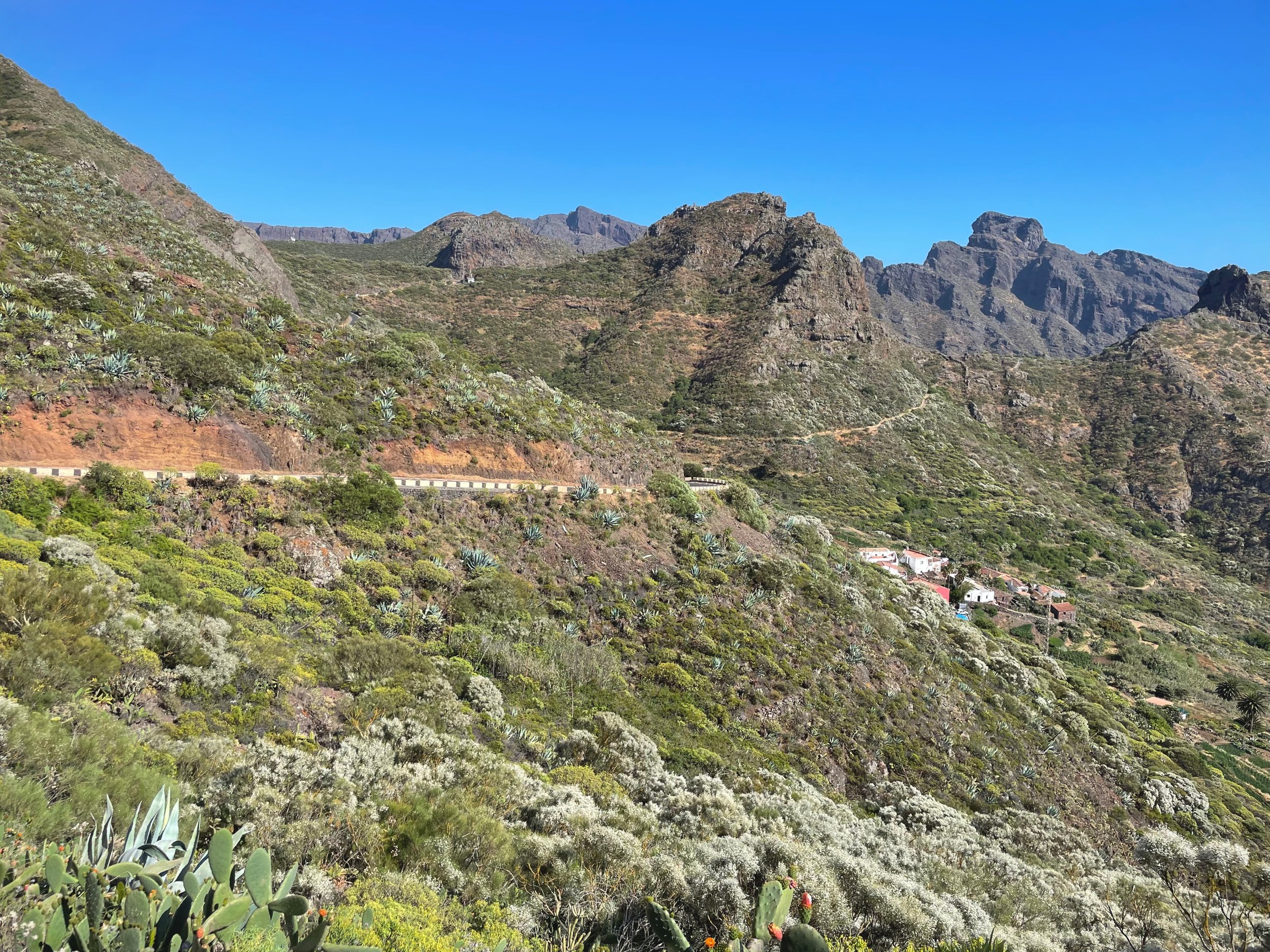

Masca is tiny, and the main road hugs the side of the mountain. Although I didn’t continue down to village streets, I took in the views from above. To the south, though, was the infamous climb out of Masca that I had to climb to get back to Los Cristianos. The climb is 2.5 miles (4Km) long with an elevation gain of over 1400ft (+426 m) and an 11% average gradient.
Oh, did I mention that this climb has a 0ft elevation loss? It's all up.
Now I brought my lights with me, knowing I’d be riding in the dark, so I didn’t have to rush myself, especially with this climb after a week of more than 30K ft of climbing. Long story short that was one of the hardest climbs I’ve ever done. The start wasn’t that bad, but halfway through, my sweaty palms and gradients made things interesting. Regardless of the case of noodle legs I had that day, that climb should be on your bucket list if you ever consider riding in Tenerife.
I don’t think I can do it justice by just writing about it, so here are some outtakes of the climb that perhaps showcase what I want to say.
The Climb:

The start of the climb
Seriously, this is a one-of-a-kind climb.
And I can't wait to suffer up it again, with a tailwind both pushing me around and carrying that sweet floral smell from the valley below.
At the summit, I rested for a min. Luckily, there was a food truck at the top, so I topped off my electrolytes with two cans of Aquarius and descended the other side back into Santiago del Tiede.
The long descent started from the summit, across town, and down the longest set of switchbacks I had ridden thus far. With the humongous ridges to the north and south, the view west was something out of this world. The Atlantic Ocean ahead of me, the sun nearing the horizon, and the silhouette of other islands doting the scene with their majestic presence.

I let go of the brakes and let gravity do its thing.
Descending the narrowing valley as the mountains got taller above me, with the Atlantic breeze rushing through, is ahhh, yeah, not sure how I can describe that either. Magical? Surreal? Out of this world? Not sure, honestly.
What I can speak to is how I felt. Do you know the feeling when you’re listening to a new song on a walk, a ride, or even a long drive? That tune progresses into something you instantly knew would be your new favorite song for the next two weeks. Blood rushing into your extremities, goosebumps all over, a warm feeling in your chest and gut.
I mean, everything was right and so unique.


I reached the bottom with a full heart and eagerness to visit this beautiful part of the world again soon. On the last leg of the ride, I paralleled the Atlantic to the west and the mountain to the east as I rode south toward Los Cristianos.
Rolling hills, fast twisty descents, and sharp kickers along the way made it more exciting and challenging. Soon after, I reached my Airbnb, still buzzing from what I had experienced that day.
Holy cow, what a ride.
Tenerife, our story is not over, and I’ll unquestionably see you again!
