

Exploring The Western Taurus Mountains: Bakırlı Dağ

Bakırlı Dağ
From the Mediterranean Sea to the upper plateaus, I ventured on a journey every other day or so during my time in Southern Turkey. The Western Taurus Mountains are one of three sections of the Taurus range extending from west of Antalya to southeastern Turkey and into the Levant within the watershed of the Euphrates & Tigris Rivers.
The Mountains sit on top of the convergence zone of three tectonic plates. Millions of years of collisions helped form the most rugged mountain range I’ve ever set foot on. No other place I’ve been to offers climbs from sea level up to +8300ft in under 23 miles.
A simply mind-blowing fact to see and experience in real life.
Until my trip to Antalya, aside from the layovers in Istanbul airport, I had never set foot in this part of the world. Crossing between my home country in the east, Kuwait, and west, where my heart lies, in Portland, OR.
Evidently, I had to do my homework. I spent at least 20 hours reading and exploring all the maps, mostly RideWithGPS. I needed to understand the nature of riding in Antalya. However, for some reason, I couldn’t find sufficient data to speak to that in a detailed manner.
That kindled my curiosity even further.
Although I did find a plethora of information about the Tour De Antalya, I needed help finding data on road conditions, riding restrictions (aka, where we are allowed to ride v. not), and the local cycling scene. For example, I rely heavily on heatmaps, not necessarily to know where the good routes are, but to understand what is and isn't off limits.
There was little around the Western Taurus Mountains, aside from a faint trail of that red line far and few in between. But, then again, exploring it yourself is the best way to find out.
A week into my trip to Antalya, it all started making sense. The Western Taurus Mountains territory is a geological, historical, and cultural wonder. The mountains rise sharply from the coastline like a giant wall separating the sea from the inland. From a close distance, it is hard to distinguish where the clouds start and where the mountains end due to their light color and staggering elevation.

The Ride:
A few days before the ride, I rode up to a ridgeline separating two valleys, Çandır Stream Valley to the east and Altınyaka Valley to the west. I stopped to check out the Çandır Stream valley from above, and I couldn't help but notice a peak rising behind a mountain on the horizon, topped with what seemed like a building reflecting the sunlight.
A quick Google Maps search showed that it was the TÜBİTAK National Observatory. Some photos on that Google map page showed a gravel road leading up to the summit. That locked it into my head.
As soon as I returned from the ride, I dug through the maps, segments, and accounts of riders I could find publicly online.
My suspicions were confirmed; that was a rideable route to the top.
I had two options: the first was to climb up the main highway, and the second was to take the backroads. The route I built climbs up from the back end towards the skiing town of Saklikent, where the observatory sits atop. I opted to avoid ascending the main road since it was busy and arduous to climb, as I had climbed it earlier in the week.
Hurma to Saklikent:


The route starts in the residential neighborhood of Hurma, as close to the foothills of the Western Taurus as you can get. The first few miles pass through a few villages on the main road. The smell of smoke early in the morning from the local restaurants firing up their iron ovens on which they cook Gözleme (turnover).
The sight of the first set of switchbacks announces the beginning of the brutal climb. When measured from this point, the climb is 22 miles long, with about 8000ft of climbing and an average of 8% grande throughout.
The climb kicks off with steep grades right off the bat, under the shade of Turkish Pine, which dominates the lower elevations. However, given the steep roads, you will only be there briefly.
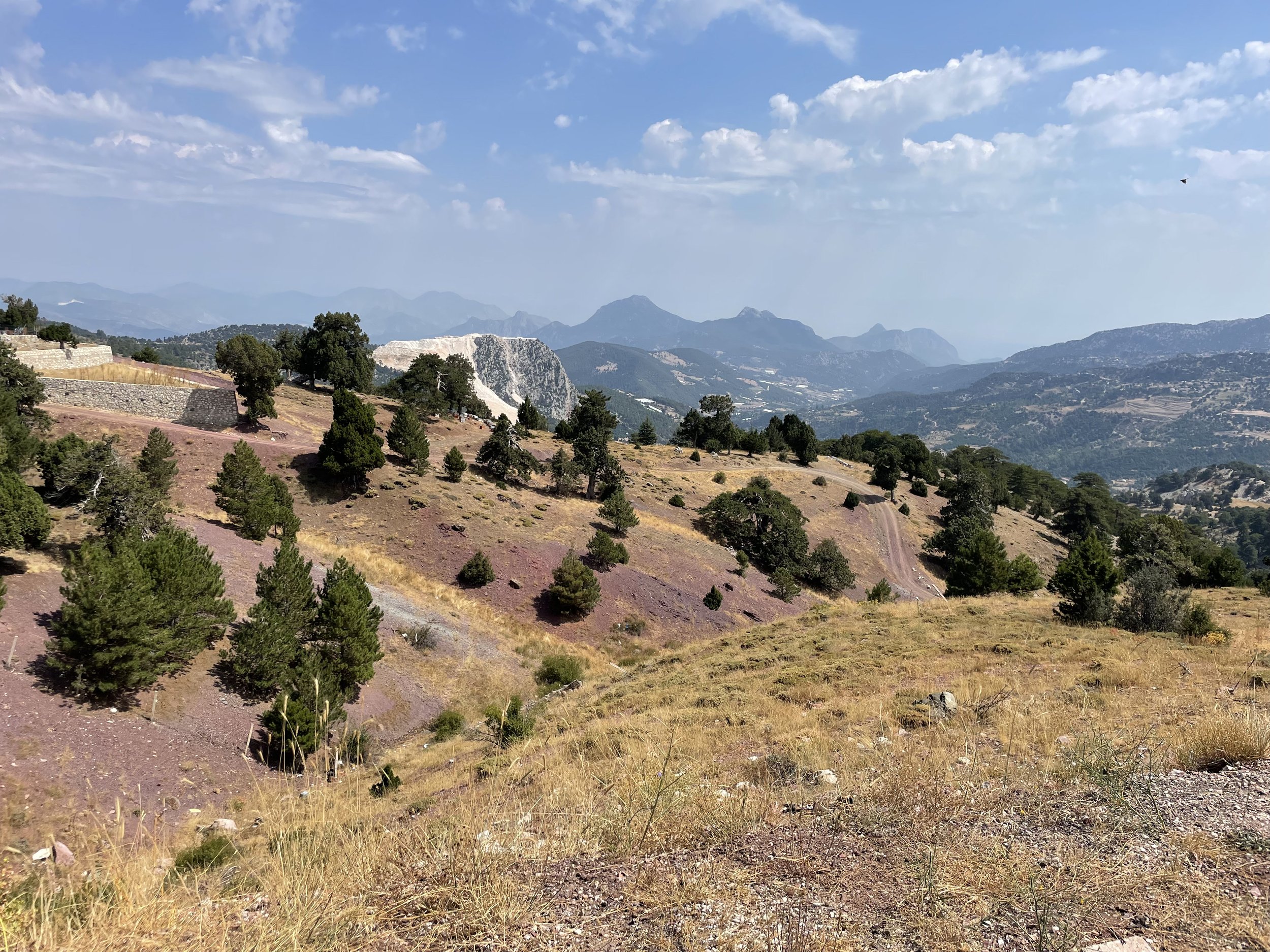
The climb is dominated by viewpoints of the appropriately named Sivri Dagi (pointed mountain), standing tall at the frontline, looming over the villages below—a view you must see in real life to feel the magnitude of these mountains.

The road hugs the cliff side of Geyikbayırı Caves on the north, above the canyon where the Lycian way (a long-distance hiking trail) cuts through.
Riding up the Taurus Mountains reminded me of Glacier’s national park in Montana. The resemblance of the structure and cragginess between Sivri Dagi and Mount Oberlin is mystical. But, just like riding in Glaciers, the Taurus Mountains too offer an almost complete view of the road to the first summit.
A few miles up the road, I reached one of many springs found all over the mountain range, either naturally seeping out of the rock or by a manmade water fountain. Fresh and chilled mountain water, as if I needed another reason to love this ride already!


Further up, the road contours the head of the valley above the Geyikbayırı village that’s nestled just below the road. Looking east, you can see what you just climbed and most of the gulf of Antalya.
I’ve seen beauty before, but that view took it to a new level.
The second set of switchbacks is just above the village, a rather steep road to the first summit. A ridge that runs north-south, separating the wilderness from the eastern face side of the mountain.
At mile 13, I climbed over 3600ft and still had over 5000ft to climb, which is hard to wrap your head around.


Reaching the pass (first summit) felt like a milestone. I stopped to catch my breath at the top before descending to the other side of the ridge. It struck me that I was probably standing in the same place where many nations were. I wouldn't be wrong to describe this place as the land of the dozen ruins, as there was an ancient city around every corner.
The number of ruins within the Taurus Mountains is baffling. I couldn't help but wonder how many millennia-old trees exist today that lived through past nations, such as the Romans that occupied this land.
After all, The Taurus mountains were once known to be the home of many Greek gods, such as Artemis and Zeus.
The descent to the other side was short-lived since the grades picked up shortly after. The upper valley was covered in farmlands scattered between Black and Turkish pine patches.
A few miles up the road, the pavement turned gravel. I reached a water crossing at the edge of Sinan Mill, a tiny village with dilapidated 300-year-old huts they used to store wheat. A true hidden gem up in the mountains stuck in time.


I continued up the steep hill past Sinan Mill, where the roads were a mix of gravel and pavement. Before reaching the main road, I stopped at a tiny mosque built against a huge boulder covered by an even bigger fig tree. I had stopped there earlier in the week to fill up on water from the spring that springs from underneath the mosque.
Leaving the mosque with fresh water in my bottles, I turned left onto the main road for the long and steep climb up to Saklikent. Given the high elevation and the gain in such a short distance, I started to crack. I had left the tree canopies of pine and entered the timberline zone.
For the next four miles or so, I stopped under trees more times than I could count. The elevation, hunger, and lack of fitness (I took a 3-month hiatus from biking in Kuwait) started to get to me. However, I didn't know that a monster of a climb was around the corner, quite literally.


I pushed forward around a hairpin just to be met with a +15% climb at +5500ft under full August sun. I was cooked.
However, as tired as I was by then, the views were taking my mind out of the pain cave. I saw a few trees that piqued my interest as I had never seen something like that before, so I stopped to check them out.
A quick Google search revealed that the tree I was under was Lebanese Cedar—one of the most important trees to many civilizations that roamed these lands. I remember reading all about it in history classes in elementary. This tree's religious and historical importance to many Middle Eastern cultures made me curious about it.
As I pondered the tree I was under, some clouds rolled under the sun, bringing much-needed relief from the harsh summer sun. I took advantage of that to get over the hump separating me from a refueling stop I had planned on the route.
With Gözleme on my mind, I reached the family-run restaurant with a million-dollar view of the valley below, overlooking many species of pine and Cedar.


I’ve come to be fond of people on the mountain, with their gentle, laidback demeanor. The lady welcomes me in, and I proceed to order with the very little Turkish I had picked up over my time there and from what I could recall from college days (I chose Turkish as my language requirement)
The smell of burning pine logs, Gözleme, and Turkish tea filled the area.
At +6000ft, the temperatures were more than pleasant, taking the edge of the remainder of the first leg of the route. I was close to Saklikent at that point, only about a few miles up the road through a town that both boasters newly built villas amongst run-down buildings, a repetitive scene all over Antalya.
Eventually, I reached the ski resort town, marking the second milestone of the day.
Saklikent to the observatory:


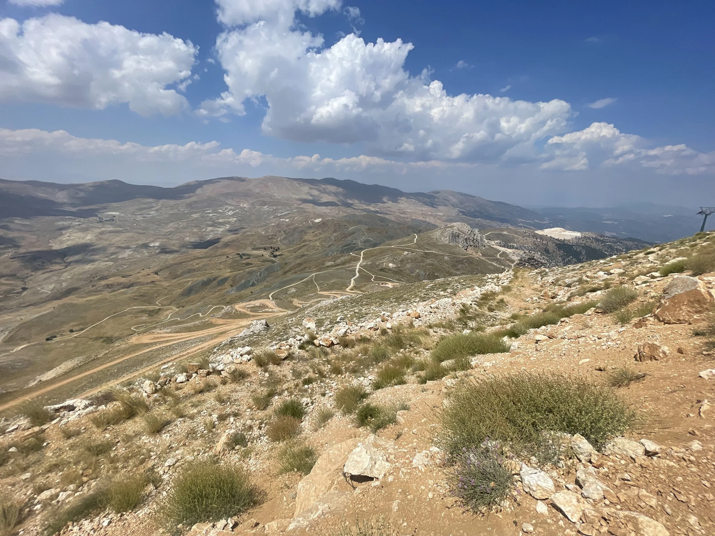
I’ve entered the highlands of the Western Taurus mountains. The clouds that shaded me from the sun earlier somehow followed me up to that point, occasionally colliding with Bakırlı Dağ (Copper Mountain), on which the observatory crowns.
Half a mile up the road, the pavement ended, and the chunko started. Although it was smooth at times, it wasn't primarily the case. I didn't have the best setup for the second part of the route, but I managed to make it work nonetheless. I had tubed 28mm Conti tires, 34x30 gear range.
That set-up got me to the base of the final climb without much trouble. However, throw high elevation, tired legs, and sandy back roads into the equation, and you have a proper adventure.
The gravel road turned around a tight hairpin with significant elevation gain. I picked a line and stuck with it past the first hump. A mile or so down the road was a surprise hidden behind the horizon.
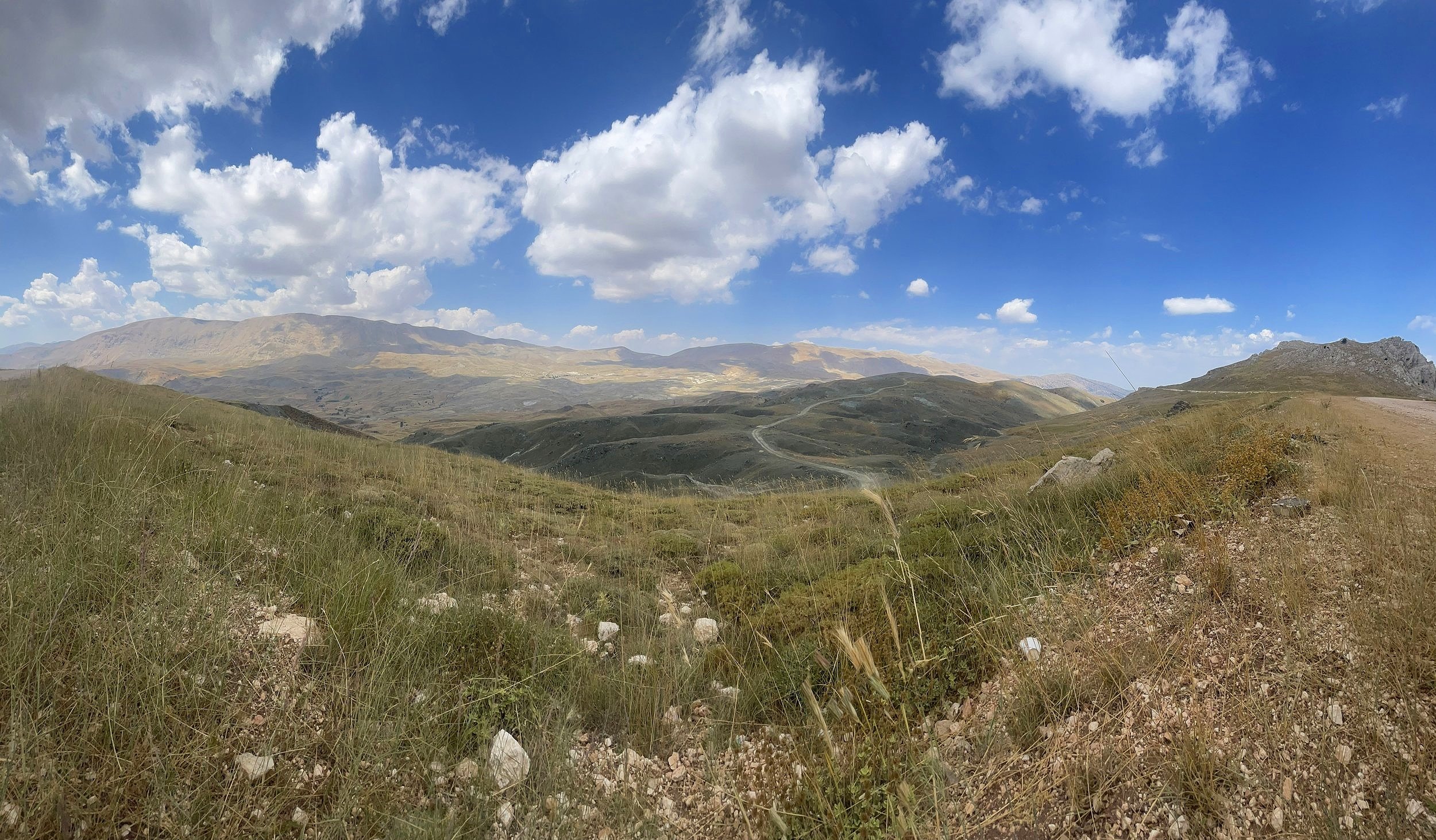


A col separating Bey Dağı (Bey Mountain) to the west and Bakırlı Dağ (Copper Mountain) to the west. The view stopped me in my tracks, and I couldn't sit around for a solid 10 to make sense of what was in front of me!
The clouds were forming over both mountains and washing down towards the coastline, a thunderstorm a-brewin?
Not gonna hide the fact that I questioned whether I really wanted to climb up the last set of steep, chunky gravel switchbacks. But I couldn’t allow myself to be so close and not push through the last few miles.
My legs were destroyed by that point, and I didn't want to risk damaging my road bike on the chunky gravel. So I took my sweet time climbing every switchback, checking the views as I did.
A few trucks passed, but the conversion didn't amount to anything beyond a few words and non-verbal communication due to the language barrier. I really need to pick up on more Turkish. The rest simply waved as they drove by.


Nearing the summit, the last set of the final switchbacks got into the double-digit grades at +8000ft. I looked at my wahoo, which read 18% at some point, and that's when I knew I had to get off the bike and start pushing.
My 28mm tires were digging into the gravel, which was an unnecessary effort to maintain. Luckily, however, as I passed the ski lift machines at the summit, the grades evened out a little for me to finish the ride riding my bike.
The summit*! I’m here! I made it!
*the public is only allowed to climb up to the observatory gate, which sits about 100ft below the actual peak.

As I rolled closer to the gate, a few guards at the gate were standing there with their guns, looking mighty tough, but as I got closer, they gave me the ok to rest by the sign and snap a photo.
I would've loved to stay up there for longer, but remember those clouds forming just above the col? Yeah, that turned out to be a thunderstorm, indeed.
The sudden drop in temperature made me suspect that, but the rumbling of thunder confirmed those suspensions!
I made it down the switchbacks just in the nick of time before it started to drizzle a bit.

With the climbing all done (aside from the short hills on the descent), I tucked in for the long drop back down to Hurma, where I started. Paying the climbing toll is rewarding, and this descent is easily a bucket list ride (contingent upon riding to the summit, of course!) that I can’t wait to ride again!
As I dropped down in elevation, passing through the different high plateaus, ridges, and valleys with many scattered villages on the mountain’s side. Some were new, while others were as old as some of the nations that trekked the same mountains I descended.
In hindsight, I’m glad I opted to go down the main road rather than the back road. Knowing that it's paved without many tight hairpins is the perfect road to descend. It's also because I had climbed it earlier in the week. It was simply too strenuous to couple it with the climb to the observatory. The balance between the ideal route and an utterly unnecessary challenge depends on what you are looking for, and for me, that was to experience the land as I climbed through the back roads.


My overall impression of this route and ride is, “Why isn't Turkey on the map of the cycling world?” I spent time riding in the PNW, California, and Spain, and what I experienced during my two weeks in southern Turkey was so beautiful, unique, and mystical.
To remind you, this is just the western part of the Taurus mountains. I only wonder what the center and southeastern parts are hiding. I barely scratched the surface, and I’m already hooked.
The next time I visit Turkey, I’ll leave the road bike at home and instead get my adventure long hauler, the Breadwinner B-road. The paved roads leading up the mountains were great. However, the forest and highland roads up and in between the countless peaks in the Western Taurus piqued my interest.
I can’t wait to ride on top of some of the tallest mountains and highest plateaus in the Mediterranean, illuminating that heatmap one ride at a time.