
Signs from Above

Some may ask, ‘Why do such a thing?’ I assume the response is something to the order of, ‘Because they are there.’ - Chris Pelto
In 2019 and then again in 2022, I rode around my hometown of Portland, Oregon looking for signs declaring 500’ and 1000’ elevations, creating a route to connect those signs. Before getting to the “why?” of that endeavor, we need to backpedal a bit to understand the “what?”

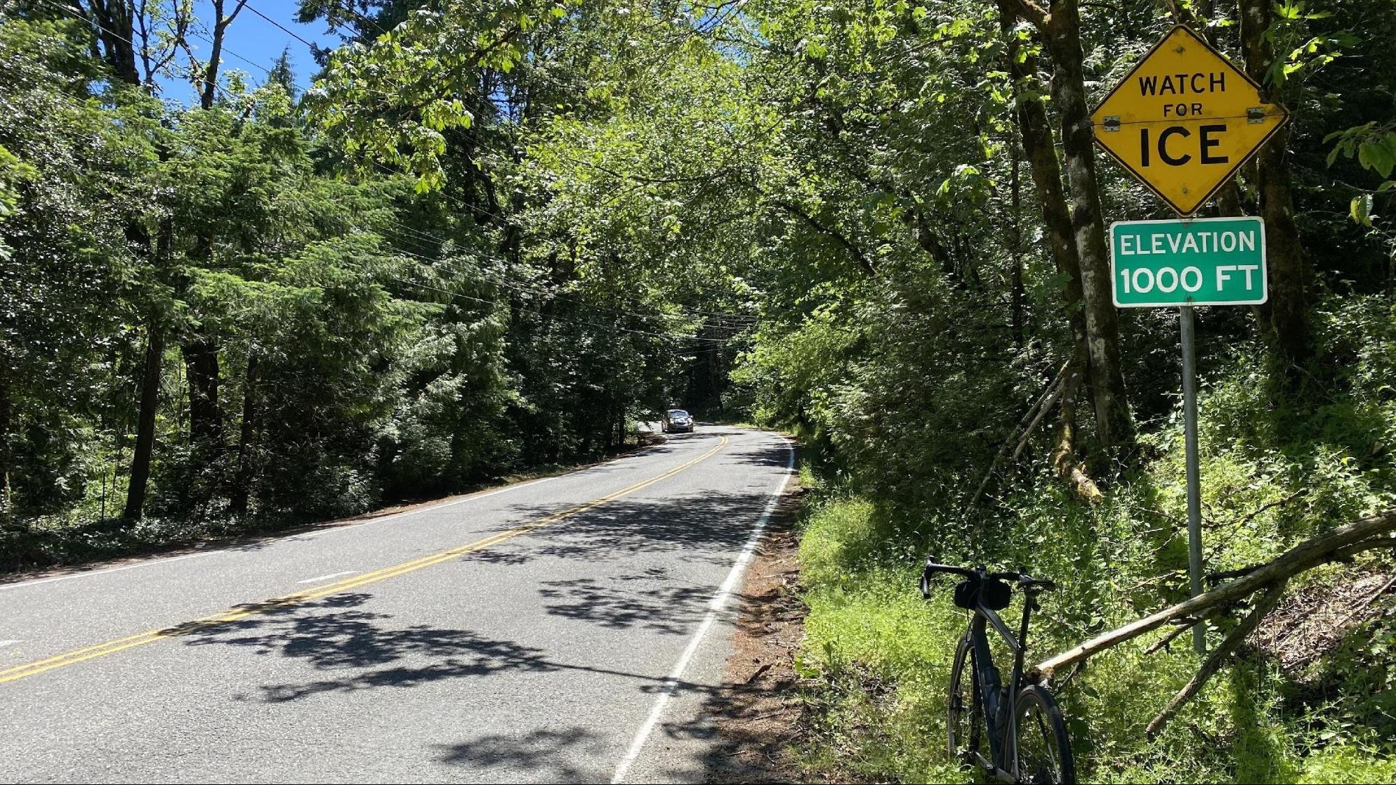
The easy answer to the “what?” is the many 500’ (and, later, 1,000’) elevation signs I started encountering on rides around Portland. Although I cannot exactly remember when I first saw one of those signs, I have a distinct memory dating to at least 2018. I snapped a pic, maybe posting it to the Gram. Then I saw another. And another. At some point, this was becoming a thing, but I did not initially know quite what to do with it.
Over the years, I have had a few other cycling “photo projects” going. My favorite continues to be the #8mile project, in which I will stop at any Mile 8 sign I find on a ride and post a picture of it.

These “ELEVATION 500 FT” signs, on the other hand, just sort of nagged at me but did not clearly announce their importance. I would need more coaxing.
Unfortunately, for me, that coaxing came in the form of three months off the bike in mid-2018 as I recovered from a cycling-related injury. And when I say “off the bike,” I mean strict orders to stay off the bike (and my right leg) for that entire time. Given that injury had resulted from a cycling accident, I spent those three months doing a deep dive into what cycling meant to me. I seriously considered giving it up and finding a new hobby.
But that thought lasted no further than the day the doc told me I was cleared for “light exercise.” I went home, hopped down the stairs to the basement on one leg, and got on the bike on a trainer. The bike that had put me in the ER would build me back up. The bike would fix what it had broken. But it took time.
During that time, I focused primarily on recovery and less on signs and pictures. But as 2018 turned to 2019, I was healthy again and looking for new challenges. And then I saw one of those signs, and those old questions came rushing back. Those signs would coax me back to combining all of the things I loved on the bike, which would include taking pictures, making interesting routes, and exploring.
Like others later would ask me, I also wondered “why?” so I turned to Google, which took me to Twitter. I found a tweet from December 2017, in which the Portland Bureau of Transportation (“PBoT”) indicated it had placed 50 of these signs around Portland at both 500' and 1,000’ elevations, apparently as a way to inform people about their current elevation because inclement weather reports in Portland are often tied to elevations.

Knowing 50 or so of these signs were to be found around town was the moment this project was born. These photo projects are tricky. If the subject is ubiquitous (a stop sign, for example) it is pointless - you might have to find hundreds of them, and they are not very interesting. But 10 or fewer of an item is probably not enough unless the route is great or the theme is compelling. 50 was a great round number. Now I had something.
I started to see this as a scavenger hunt. I wanted to gamify it. I posted in the local OMTM Google group asking how I could go about finding where streets crossed over 500’ and 1,000’ elevations. Some told me to ask PBoT. That was too easy. The act of finding the signs, primarily on my own, would be part of the project.
In the end, local route-making legend, Ryan Francesconi, sent me a topo map that did the trick. (Ironically, had I carefully read that 2017 PBoT tweet, I could have found something similar.) For the next several weeks, I would add these intersections of streets and elevations to my rides, whether on commutes or out on a solo weekend ride.
I started cataloguing these with Strava (and Instagram). I had 20 by May 2019. They would come in bunches and then I would go on a cold streak.
Sometimes I was surprised to find a sign in a place that seemed unnecessary, but usually, I was more surprised to find the absence of a sign in a place that seemed appropriate. For example, there is a location above 500’ near Barbur and Capitol Highway that seems like it needs a sign, but I could never locate one.

After finding approximately 50 on the westside and another half dozen or so on the eastside, I set out to make a route to connect all of them. This opened a whole new adventure.
For those of you who design cycling routes, you probably have some rules you go by. For example, we call one friend The Rule because he instilled in us early on that a good route must be a loop and cannot overlap. So I started with that rule. But “rules” in cycling are controversial, so I looked at them as “preferences.”
This project challenged me to come up with my own route-making preferences. For example, I wanted to approach these signs face-on so they could be seen while riding. But that preference fell away when I found a sign here or there that was on a climb on a busy street with little or no shoulder. Those would need to be approached from behind while descending. Safety would win over convenience.

I wanted the route to hit the so-called “golden ratio” of 100’ climbing per mile of riding. The route would need to go through some “connectors” here and there and maybe even a little dirt or gravel. The route should include a Dead End and/or a No Outlet. For those of you in Portland, think of the Ronde and the other routes inspired by Devin Bailey. And a Mile 8 sign would be the cherry on top.
The ride should be a challenge and not a soul-killing death ride - but, it should have that option if that is your path. This led to the most controversial decision, as I would separate the signs on the westside of Portland from those on the eastside.
In the end, I wound up with a nice “loop” of about 8,300’ over 63 miles. I rode that route, stopping at each sign to IG story post the experience, and then posted the ride, with the pictures, to Strava.
The reaction was quick and gratifying. A few friends asked about putting together a group ride. But then another cycling injury, another recovery … and then the social isolation of The Vid Times. Time passed. I figured this project was completed.
Not so fast. One of those friends who had been watching all of those shenanigans in 2019, Abe Alkhamees, reached out and asked me about this route and what had become of it.

I found the route in my Ride with GPS library and remembered I had left an unresolved “problem” on that route. Somewhere along the line, I came across the Long Tiny Loop and its many rules and intricacies. One of those had to do with something I call “the knuckle”: basically, you cannot come to an intersection and do a 90-degree turn on one corner, only to later approach that same intersection from the opposite corner, creating a knuckle at that intersection. And remember The Rule? He had a similar requirement that one time led to a healthy debate on a ride with our mutual friend, Chad.
Now I had a new challenge. I set out to remove the knuckle and rethink the project I had thought was finished in 2019. Also, I wanted to know how many of the signs had disappeared or been removed because I had noticed a couple were missing.

I cleaned up the route and rode it in June 2022. Similar in stats to the earlier route, the new version eliminated the knuckle and wound up with a better overall aesthetic. The route contains a close call near Ida B. Wells HS, but I intentionally left that in there because that area affords good opportunities for food and beverages early and later in the ride.
Yes, some of those signs are now gone - quite a few, in fact. Some appear to have been stolen, which I surmised from the presence of empty sign brackets. It seems like PBoT would have taken those brackets if it had decommissioned a sign. Others I just could not find. A couple were on busier roads, so I did not linger to perform an exhaustive search. But I do wonder if some were intentionally removed. That will remain a mystery because every good tale deserves an unresolved question near the end.
I will also leave those locations in the route, even though no one will find a sign there in the future. The project was about those signs, and at one point, a sign could be found in each of those locations. With that, I think this project is complete.
Finally, like any good looping route, we must return to the start: the “why?” of the whole thing. But that’s obvious - because they are there.